What Is the GNSS Toll System?
The Global Navigation Satellite System (GNSS) is a sophisticated technology that relies on a network of satellites to provide location and timing data to users worldwide. GNSS is widely known for its applications in navigation, and recently, it has found its place in toll collection systems as well. The GNSS Toll System refers to the use of satellite signals to track and charge vehicles for tolls as they travel along highways, expressways, or roads.
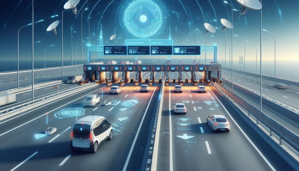
Unlike traditional toll systems, which require drivers to stop at toll booths or use RFID-based FasTags, the GNSS toll system operates in a more seamless, efficient, and automated manner. With GNSS, vehicles are automatically tracked via satellite, and toll charges are calculated based on the distance they travel. The technology brings an entirely new level of convenience and efficiency to toll collection, reducing congestion, eliminating the need for physical infrastructure, and streamlining the entire process.
How Does the GNSS Toll System Work?
The GNSS toll system operates using a vehicle’s On-Board Unit (OBU), a GPS-enabled device that communicates with satellites to calculate the vehicle’s position and movement. Here’s a step-by-step explanation of how it works:
- Satellite Communication: The OBU installed in the vehicle constantly communicates with the GNSS satellites. These satellites send signals that provide accurate data about the vehicle’s position and speed.
- Tracking Vehicle Movement: As the vehicle moves along the toll road, the system continuously tracks its position. The GNSS technology uses the time it takes for signals to travel from the satellites to the vehicle to calculate the exact location.
- Distance and Toll Calculation: The system calculates the distance traveled by the vehicle on the toll road and computes the toll charges based on predetermined rates. This eliminates the need for manual toll collection and long queues at toll booths.
- Automatic Payment: The toll is automatically deducted from the vehicle owner’s account. Payments can be linked to a digital wallet, credit card, or even a government-backed account.
- Seamless Travel: With no physical toll booths or barriers, vehicles can travel freely, and tolls are paid automatically. This reduces delays, fuel consumption, and the overall stress of travel.
Advantages of the GNSS Toll System
The GNSS toll system offers several significant advantages over traditional toll collection methods:
- Convenience and Efficiency: One of the most notable benefits of the GNSS toll system is the convenience it offers. Drivers no longer need to stop at toll plazas or manually pay tolls. The system works seamlessly, saving time and reducing traffic congestion.
- Cost-Effective: Traditional toll booths require infrastructure, manpower, and maintenance costs. The GNSS system, by contrast, reduces the need for physical infrastructure, making it more cost-effective in the long run. Governments and toll operators can save on operational costs.
- Environmentally Friendly: Since vehicles don’t have to stop and start at toll booths, fuel consumption is minimized. This contributes to a reduction in emissions, making the system more eco-friendly.
- Transparency and Accuracy: The GNSS system ensures that toll charges are accurately calculated based on the actual distance traveled. The automated nature of the system makes it transparent and reliable, reducing errors in toll collection.
- Reduced Congestion: As there are no physical toll booths or barriers, the overall flow of traffic is smoother. Vehicles don’t need to slow down or stop, reducing congestion at toll plazas, especially during peak travel times.
Disadvantages of the GNSS Toll System
While the GNSS toll system brings a host of benefits, it does come with a few challenges:
- Privacy Concerns: One of the major concerns surrounding the GNSS toll system is privacy. Since the system tracks vehicles in real-time, it raises questions about how data is stored, who has access to it, and how it is protected. Continuous tracking of vehicles may be seen as an invasion of privacy by some users.
- Technological Challenges: GNSS technology relies on satellite signals, which may sometimes be affected by atmospheric conditions or obstructions like tall buildings or tunnels. In such cases, tracking accuracy can be compromised, which might lead to issues with toll calculations.
- High Initial Setup Costs: While GNSS toll systems can be more cost-effective in the long term, the initial setup involves significant investment. Governments need to invest in infrastructure, technology, and devices like OBUs, which can be expensive.
- Adoption and Infrastructure: The transition to GNSS-based toll collection requires significant changes to existing infrastructure. This can be a challenge in countries with extensive road networks, requiring modernization efforts across multiple states or regions.
Will GNSS Toll Systems Replace FasTags?
The GNSS toll system and FasTags serve similar purposes—automating toll collection—but they use different technologies. FasTags are based on Radio Frequency Identification (RFID) technology, where a tag on the vehicle communicates with a reader at the toll plaza. In contrast, the GNSS toll system uses satellite signals to track vehicles.
While the GNSS system offers many advantages over FasTags, it is unlikely to fully replace them in the near future. FasTags are already widely used in India and many other countries, and their implementation has been successful in reducing congestion and streamlining toll collection.
That said, as GNSS technology matures and expands, it could complement or replace traditional systems in some regions, especially where infrastructure for satellite-based tolling is more feasible. In some places, GNSS-based systems may be used for long-distance tolling, while FasTags may remain in use for more localized toll collection.
Why Is the GNSS Toll System Being Implemented in India?
India has been actively looking for ways to modernize its transportation infrastructure, and the GNSS toll system is part of that effort. With one of the largest road networks in the world, India faces significant challenges in managing toll collection efficiently. The GNSS toll system offers several advantages for India’s evolving transport ecosystem:
- Reducing Traffic Congestion: India’s toll plazas are often congested, especially during peak hours. The introduction of a GNSS-based toll collection system will help alleviate this congestion by eliminating the need for vehicles to stop at toll booths.
- Improving Efficiency: With growing traffic volumes, traditional toll collection methods are becoming increasingly inefficient. The GNSS toll system can streamline the process, ensuring a smoother and more efficient experience for drivers.
- Boosting Digital Infrastructure: India is focusing on digitizing its public infrastructure, and the GNSS toll system is part of this larger vision. It aligns with the government’s push to create a cashless, digital economy, reducing the need for physical payments and paperwork.
- Environmental Benefits: By reducing fuel consumption and emissions caused by vehicles idling at toll booths, the GNSS toll system will contribute to India’s environmental goals.
Challenges in Implementing the GNSS Toll System in India
While the GNSS toll system offers clear benefits, its implementation in India comes with a set of challenges:
- Infrastructure Development: The implementation of GNSS-based toll systems requires extensive infrastructure investments, including setting up satellite tracking systems and installing On-Board Units in vehicles.
- Technological Access: In rural areas, where technological access might be limited, the GNSS toll system could face hurdles. Ensuring that the technology is available to all vehicle owners will require careful planning.
- Data Privacy Concerns: The collection and storage of real-time vehicle location data raise privacy concerns. It will be important for the Indian government to establish clear regulations around data protection to ensure user privacy.
FAQs on GNSS Toll System
- How Far Is the Toll-Free Distance? The toll-free distance varies depending on the specific toll policies of the country or region. In some areas, there might be a certain distance where no tolls are charged, or the first few kilometers might be free.
- Which Countries Have GPS-Based Toll Collection? Countries like Germany, Austria, and Singapore have already implemented GPS-based toll systems. India is working on adopting similar systems to modernize its tolling infrastructure.
- What Is the Full Form of GNSS? GNSS stands for Global Navigation Satellite System.
- How Does GNSS Measure Speed? GNSS uses satellite signals to track the position of a vehicle. By comparing the changes in the vehicle’s position over time, the system can accurately calculate the vehicle’s speed.
- What Is an OBU (On-Board Unit)? An On-Board Unit (OBU) is a GPS-enabled device installed in a vehicle. It communicates with GNSS satellites to track the vehicle’s location and calculate toll charges based on the distance traveled.
Conclusion: The Future of Toll Collection
The GNSS toll system represents a leap forward in the evolution of toll collection methods. With its ability to reduce congestion, improve efficiency, and lower costs, it’s clear that GNSS is the future of tolling. While challenges remain, especially in terms of infrastructure and privacy concerns, the widespread adoption of this technology is inevitable as countries like India strive to modernize their road networks. As GNSS tolling systems become more prevalent, drivers will experience faster, smoother, and more cost-effective travel, benefiting both the economy and the environment.